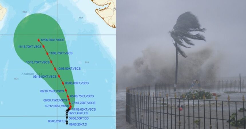
Cyclone Biparjoy, the first storm of the year in the Arabian Sea, has rapidly intensified into a severe cyclonic storm, according to meteorologists. It is expected to bring a “mild” onset of the monsoon over Kerala and “weak” progress beyond the southern peninsula. This storm, the second named cyclone of the 2023 North Indian Ocean season, follows Cyclone Mocha, which affected Myanmar and parts of Bangladesh in May.
Similar to Cyclone Mocha, Cyclone Biparjoy is also projected to bypass India’s mainland. However, it is likely to cause weather disturbances and rainfall along the western coast. Here’s what we currently know about Cyclone Biparjoy as of June 7th.
Projected Landfall
Cyclone Biparjoy is anticipated to make landfall in Pakistan. As of June 7th morning, the weather office reported that the depression was approximately 1,370 km south of Karachi. This landfall will affect the arrival of the monsoon in Mumbai, which heavily relies on rainwater to fill its water reservoirs.
The Indian Meteorological Department provided an update stating, “The cyclonic storm moved nearly northwards at a speed of 2 kmph in six hours, intensified into a severe cyclonic storm, and was centered over the same region at 5:30 am. It was located about 890 km west-southwest of Goa, 1,000 km southwest of Mumbai, 1,070 km south-southwest of Porbandar, and 1,370 km south of Karachi.”
According to the IMD, the storm is expected to continue moving nearly northwards, intensify into a very severe cyclonic storm, and then shift in a north-northwest direction over the next three days. However, no significant impact on countries along the Arabian Sea, including India, Oman, Iran, and Pakistan, is predicted. Fishermen have been cautioned against venturing into the seas, and warnings are expected for coastal areas.
Impact on coastal areas in India
The IMD stated that Cyclone Biparjoy is likely to influence the monsoon’s progress in India. A senior IMD scientist mentioned that the southern peninsula will experience rainfall due to the influence of the cyclonic storm and a developing low-pressure system in the Bay of Bengal. However, the further advancement of the monsoon beyond the southern peninsula will occur once the cyclone weakens.
Mahesh Palawat, Vice President (Climate and Meteorology) at Skymet Weather, explained, “The cloud mass is concentrated around this system, and enough moisture is not reaching the Kerala coast. While the criteria for monsoon onset may be met in the next two days, it won’t be a robust start.” He added that after the monsoon onset in Kerala, the monsoon will remain “weak” until the storm dissipates around June 12th.
Skymet warned, “The powerful weather system in the Arabian Sea may hinder the monsoon’s progress deep inland. Under its influence, the monsoon stream may reach coastal areas but will struggle to penetrate beyond the Western Ghats.” Initially, Skymet had predicted the monsoon’s onset in Kerala on June 7th with an error margin of three days.
Cyclone’s Path
Meteorologists tentatively expect the system to track northward. However, storms sometimes deviate from predicted paths and intensities. Forecasting agencies have noted the “rapid intensification” of the storm. According to the Joint Typhoon Warning Centre (JTWC), an agency of the US Department of Defense that issues tropical cyclone warnings for the Pacific and Indian Oceans, Cyclone Biparjoy has intensified by 40 knots (74 kmph) since Tuesday morning.
VSCS BIPARJOY over eastcentral Arabian Sea, lay centered at 1730hrs IST 07th Jun 2023, near lat 13.3N & long 66.2E, about 860km wsw of Goa, 940km sw of Mumbai. It would intensify further & move nearly northwards during next 12hrs., then move nnw-wards during subsequent 3days. pic.twitter.com/SElogeJdht
— India Meteorological Department (@Indiametdept) June 7, 2023
Scientists have attributed the rapid intensification and prolonged intensity of cyclonic storms in the Bay of Bengal and the Arabian Sea to climate change.
Naming
As with all tropical cyclones, weather forecasters assigned the name ‘Biparjoy’ to avoid confusion and maintain clear records. The name ‘Biparjoy’ was derived from Bangladesh, where it means ‘disaster’ or ‘calamity’ in Bengali. In 2020, this name was adopted by countries within the World Meteorological Organization (WMO) for all tropical cyclones forming over the North Indian Ocean, encompassing the Arabian Sea and the Bay of Bengal.


