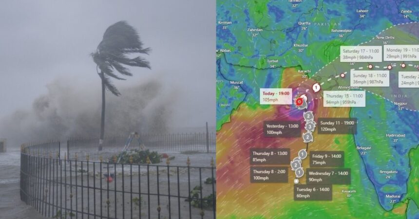
Porbandar Vavajodu Live Location Today in Map [Tracker] – The Meteorological Department has predicted that Cyclone Biparjoy, approaching Gujarat, will intensify and make landfall between Jakhou-Nalia in Kutch and Karachi in Pakistan on June 15. Wind speeds in coastal areas are expected to reach 125 kmph during June 14-15, possibly escalating to 150 kmph. Heavy to very heavy rainfall is forecasted in Kutch and Saurashtra on these days. However, the pressing question remains: When will the superstorm transition into a deep depression and weaken?
Regarding the storm’s transition into a deep depression, the IMD forecast states that Biparjoy will approach Gujarat as a very severe cyclonic storm until midnight on Thursday, accompanied by wind speeds of 120 to 180 kmph.
At midnight on the 16th, the storm will downgrade from a very severe cyclonic storm to a cyclonic storm and further weaken into a deep depression by the afternoon of the 16th. Consequently, the storm will partially lose its intensity. As the storm passes through, affected regions can expect winds blowing at speeds of 50 to 70 kmph, accompanied by rainfall.


Understanding Deep Depression:
There exists a direct correlation between hurricanes and sea surface temperatures. When a cyclone maintains a speed of 31 kmph or lower, it is referred to as a “low-pressure area.” Speeds between 31-49 kmph classify it as a “depression,” while speeds of 50-61 kmph label it as a “deep depression.”
Storm Intensification Mechanism:
Once wind speeds reach 62 to 88 kmph, the cyclone transforms into a “hurricane.” To be classified as a “severe cyclone,” speeds must range from 89 to 118 kmph. If the speed falls between 119 kmph and 221 kmph, it is termed a “very severe cyclone.” Cyclones surpassing 222 kmph are classified as “super cyclones.”
Weakening of the Storm:
As per the current data from Windy.com, the cyclone is expected to make landfall on the Gujarat coast on the afternoon of June 15. Presently, its impact is being observed in the Saurashtra-Kutch areas of Gujarat. Post-landfall, districts including Kutch, Devbhoomi Dwarka, Porbandar, Jamnagar, Morbi, Junagadh, and Rajkot will experience the storm’s grip.


On June 16, the cyclone is projected to move towards areas in Rajasthan adjacent to North Gujarat as a cyclonic storm, bringing the likelihood of rainfall according to the Meteorological Department. Concerning the weakening of the cyclone, it is anticipated to weaken further on Monday night while passing through Bhilwara and Kota in Rajasthan, and subsequently passing through Jhansi before concluding at Prayagraj.
(Disclaimer: The storm’s position and direction are subject to change in the coming days, as per Windy.Com)
Porbandar Vavajodu Live Location Today in Map Tracker
Here is the live location of Porbandar / Bipor Joy Vavajodu in real-times:


Preparedness for Potential Storms:
- Evacuation of residents in the most affected villages located within 0 to 5 km from the bank in the area between Mandvi to Jakhou in Kutch district, where the cyclone is expected to make landfall.
- Deployment of 12 teams each of NDRF-SDRF in cyclone-affected districts, with additional teams on standby.
- Suspension of vehicular traffic in storm-affected regions due to the forecast of heavy winds and rain.
It is worth mentioning that on Monday, Prime Minister Narendra Modi reviewed the preparedness of the central and Gujarat governments to tackle the cyclone’s impact. After the meeting, Modi tweeted, “Our teams are evacuating people from vulnerable areas and ensuring the supply of essential commodities. Praying for everyone’s safety and wisdom.”
Tags – Porbandar Vavajodu Live Map Location Today